Extreme-Scale Simulations for Advanced Seismic Ground Motion and Hazard Modeling

PI Christine Goulet, University of Southern California
Goulet - INCITE 2020

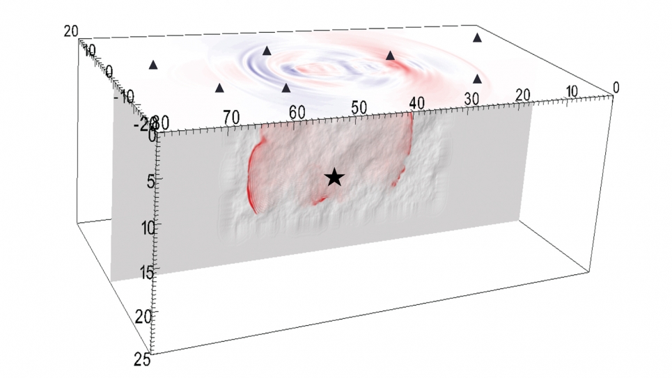
Snapshot of earthquake rupture propagation computed by the dynamic rupture code Waveqlab3D along a vertically dipping strike-slip fault with superimposed fault roughness. The image shows the progression of the rupture propagation 9.6s after the initiation at the hypocenter (star) and the corresponding ground motion velocity is shown in red and blue at the surface. These types of simulations help us better understand the effect of fault complexity on rupture propagation and on the resulting ground motions. Simulation results such as these are used to supplement empirical observations, where data is scarce, to inform seismic hazard from large earthquakes. (Image: Kyle Withers, U.S. Geological Survey/Southern California Earthquake Center)

Project Summary

With this INCITE project, researchers from the Southern California Earthquake Center (SCEC) are working to enhance their earthquake simulation and hazard mapping tools to provide the best possible information in terms of earthquake ground motion and seismic hazard.

Project Description

Accurate seismic hazard assessments help inform and prepare society for earthquakes, enabling the development of design and mitigation strategies that save lives and reduce economic losses in the event of a major earthquake. The advancement of earthquake modeling and simulation tools is critical to reducing uncertainties and improving the accuracy of seismic hazard assessments.

With this INCITE project, researchers from the Southern California Earthquake Center (SCEC) are working to enhance their earthquake simulation and hazard mapping tools to provide the best possible information in terms of earthquake ground motion and seismic hazard. This involves extending the SCEC software ecosystem, including CyberShake, for example, to the next level of fidelity by advancing its capabilities to resolve shaking estimates and related uncertainties across a broadband range of frequencies of engineering interest (i.e., 0–20 Hz).

To enable the computation of broadband seismic hazard maps, the team will improve their computational codes’ ability to accurately simulate high-frequency shaking. A significant part of the research involves the integration and testing of new and improved simulation elements in the codes to model topography, realistic material rheology and inelasticity, and the stochastic representation of the heterogeneous portions of the Earth’s crustal structure. It will also require the development of new processing workflows to address the added complexity. The larger simulation domains, higher resolution grids, and new physics models implemented in their codes will pose new challenges that can only be addressed with DOE’s leadership- class computing resources. The modeling enhancements in the SCEC software ecosystem will increase the accuracy of simulations, reduce scientific uncertainties, and broaden the usefulness of these software tools in engineering applications.

Allocations