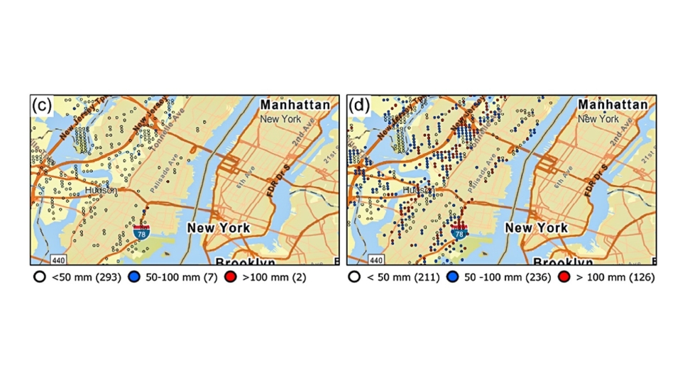
Extreme surface water depths (mm) in a 50-year event around New York in “Historic” and “Future” scenarios. (Image by Argonne National Laboratory.)
Extreme surface water depths (mm) in a 50-year event around New York in “Historic” and “Future” scenarios. (Image by Argonne National Laboratory.)
Argonne researchers and partners have developed a new methodology for estimating increased flood risk from climate change.
If you’ve lived in the same geographic location for several years, you’ve probably noticed the seasons changing. And no, not from spring to summer and fall to winter.
Depending on your region, you may have noticed spring is a bit rainier or winters aren’t producing as much snowfall as they used to. Climate change is impacting the water cycle around the world, having implications for precipitation, tropical storms, droughts, floods, sea level rise and more. Extreme weather events, like severe inland flooding — caused by extreme rain and snowmelt — are happening more frequently.
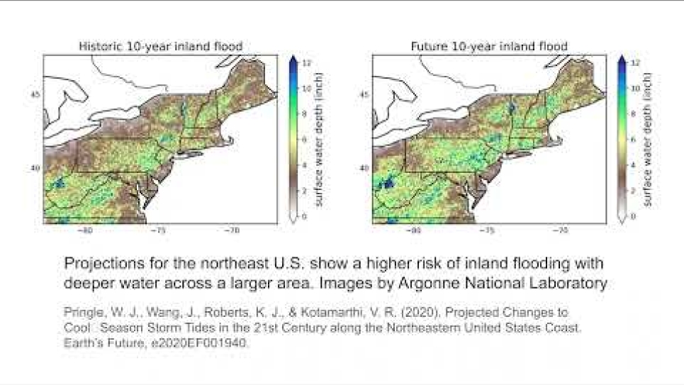
Researchers at the U.S. Department of Energy’s (DOE) Argonne National Laboratory have developed a new dataset that estimates increased inland flood risk from climate change during the mid-21st century. Their article about the dataset, published in the Journal of Hydrology: Regional Studies, looks specifically at a study of the Northeastern United States, but the dataset will soon be applied across the country and can be implemented in any global region.
The first-of-its-kind study performed six decade-long simulations using supercomputing resources at Argonne’s Laboratory Computing Resource Center and the Argonne Leadership Computing Facility, a DOE Office of Science user facility.
“We took two different climate modeling scenarios, 1995 to 2004 and 2045 to 2054, and ran three different models for each. Downscaled high-resolution rainfall data from regional climate models were used to generate inland flooding depths, which had never been done before,” said Sujan Pal, a hydroclimatologist at Argonne and lead author of the study. The high performance computing systems helped achieve a detailed, high-resolution simulation of the nation broken down into remarkably small cells, each covering an area of 200 meters by 200 meters (roughly the size of a tennis court).
The model that generated the flood risk uses data from the Argonne Downscaled Data Archive (ADDA), a dataset of physics-based climate model projections for North America at a resolution of 12 kilometers (7.5 miles). ADDA resolution is nearly 10 times better than global climate models, which typically provide estimates at 100-200 kilometers (62-124 miles). Researchers can now see how flooding might impact individual neighborhoods.
“This was the most intensive calculation of this type ever done, over such a large area, over time, and at this resolution,” said Rao Kotamarthi, science director at the Center for Climate Resilience and Decision Science. “We could not imagine doing this calculation without Argonne’s computing power.”
Agencies and industries are now considering climate change policies as extreme precipitation and flooding can pose significant risks to their infrastructures and networks. Specifically, the researchers collaborated with AT&T and the New York Power Authority to help understand what kind of data they sought. For instance, the New York Power Authority wanted to understand the risk of flooding and changes in river flows since hydropower is part of their portfolio.
“People care about flooding because it’s an impact,” said Pal. “Assessing extreme precipitation and associated flood risks at a local level is necessary for decision-making and developing mitigation strategies.”
The goal of the partnerships is to help stakeholders make decisions and help answer questions such as if assets, like those that make up the power grid, are at risk of flooding. And how will flooding depths change? “When we first connected with stakeholders in 2017, flooding data was not even on my radar, but it was the first dataset they requested,” said Kotamarthi. “We can learn a lot from these discussions because not everyone is just interested in how many degrees warmer the temperature will be.”
A new data portal, the Climate Risk and Resilience Portal (ClimRR), houses all the data from these simulations for the continental United States. ClimRR was recently launched at Argonne with support from AT&T and FEMA and won a 2023 Climate Leadership Award and an R&D 100 Award.
While this study doesn’t cover the Chicago region, it does cover other large urban areas such as Baltimore and New York. The modeling method will soon be updated and applied to research at the Chicago-based DOE Urban Integrated Field Laboratory, Community Research on Climate & Urban Science (CROCUS).
“CROCUS is urban. Everything is completely managed and not natural in any sense,” said Kotamarthi. “The next step is to take the calculations and imagine how we would look at a place like Chicago. The current simulation does not look at things like bioswales or green roofs that prevent flooding, so we are going to implement that into the model.”
The datasets will provide insights for CROCUS about how climate change may affect flooding potential or drought over the Chicagoland area, which may soon directly impact home insurance and power costs.
With these flood projections, partner neighborhood organizations can help neighbors understand their risks and inform residents on how to adapt.
==========
The Argonne Leadership Computing Facility provides supercomputing capabilities to the scientific and engineering community to advance fundamental discovery and understanding in a broad range of disciplines. Supported by the U.S. Department of Energy’s (DOE’s) Office of Science, Advanced Scientific Computing Research (ASCR) program, the ALCF is one of two DOE Leadership Computing Facilities in the nation dedicated to open science.
Argonne National Laboratory seeks solutions to pressing national problems in science and technology. The nation’s first national laboratory, Argonne conducts leading-edge basic and applied scientific research in virtually every scientific discipline. Argonne researchers work closely with researchers from hundreds of companies, universities, and federal, state and municipal agencies to help them solve their specific problems, advance America’s scientific leadership and prepare the nation for a better future. With employees from more than 60 nations, Argonne is managed by UChicago Argonne, LLC for the U.S. Department of Energy’s Office of Science.
The U.S. Department of Energy’s Office of Science is the single largest supporter of basic research in the physical sciences in the United States and is working to address some of the most pressing challenges of our time. For more information, visit https://energy.gov/science.